Exploring the Potential of Drones for Radiation Surveying
Drones and Surveying Sites
Drones are already used for a variety of tasks, including search and rescue, weather monitoring, and traffic monitoring. Besides, drones do have a significant role in radiation monitoring and the nuclear industry across the world. Currently, drones are utilized to develop contamination maps at legacy uranium sites, track and detect radiation leaks, create visual inspections at nuclear facilities, and perform unattended radiological measurements. This data could be used to decommission nuclear power plants and research facilities that are no longer in use.
Scientists at the Pacific Northwest National Laboratory (PNNL) have found that drones have the potential to conduct decommissioning radiological surveys. However, more research is needed before drones can be approved for this purpose.
The PNNL scientists published their findings in a proof-of-concept report titled “Drones for Decommissioning.” The report found that drones can be used to collect accurate radiation measurements, even in areas that are difficult or dangerous for humans to access.
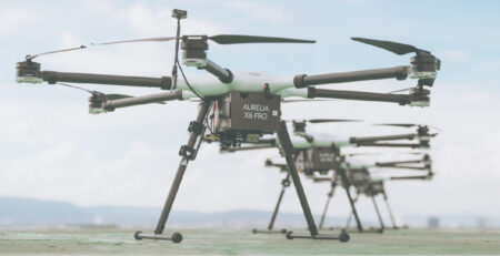
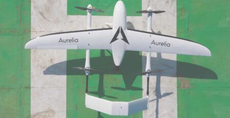
The drone used for the development was the Aurelia X6, made by Aurelia Aerospace’s dealer UAV Systems International, capable of carrying a payload of up to 11 pounds. A Federal Aviation Administration licensed pilot made the drone operate.
Potential Benefits of Using Drones for Decommissioning Radiological Surveys
The use of drones for decommissioning radiological surveys could have a number of benefits. Drones can collect data more quickly and efficiently than humans can. They can also be used to survey areas that are too dangerous or inaccessible for humans. This could help to reduce the cost and time of decommissioning nuclear facilities. Another added benefit is that survey-suitable drones could be programmed to execute remotely at a site, in the absence of constant piloting.
However, there are also some challenges that need to be addressed before drones can be widely used for decommissioning radiological surveys. One challenge is that drones need to fly low and slow to detect low levels of radiation. This can make them vulnerable to wind and other weather conditions. Additionally, drones need to be equipped with specialized radiation detection equipment.
Despite these challenges, the PNNL scientists believe that drones have the potential to be a valuable tool for decommissioning radiological surveys.
All platforms can be bought with your preferred drone software
HIGH-PERFORMANCE SERIES
Aurelia X6 Pro V2

Key Features:
- Carry up to 6 kg (13 lb) payload
- Up to 70 minutes of flight time
- Drone Rescue System (Parachute)
- Dual U.S.-Made F9P GPS Modules
- 6x Obstacle Avoidance Sensors
- Garmin LiDAR for Terrain Following
- RTK Ready
- Can be fully customized to any need
Aurelia X8 MAX

Key Features:
- Carry up to 11 kg (24 lb) payload
- Up to 50 minutes of flight time
- Octocopter 8-rotor design for further redundancy and reliability
- Can be fully customized to any need
Aurelia X6 MAX

Key Features:
- Carry up to 6 kg (13 lb) payload
- Up to 70 minutes of flight time
- Hexacopter 6-rotor design for redundancy and reliability
- Can be fully customized to any need
STANDARD SERIES
Aurelia X4 Standard

Key Features:
- Carry up to 1.5 kg (3.3 lb) payload
- Up to 40 minutes of flight time
- Quadcopter 4-rotor design, a perfect trainer drone to start out
- Can be fully customized
Aurelia X6 Standard

Key Features:
- Carry up to 5 kg (11 lb) payload
- Up to 45 minutes of flight time
- Hexacopter 6-rotor design for redundancy and reliability
- Can be fully customized to any need
Aurelia X8 Standard

Key Features:
- Carry up to 8 kg (17 lb) payload
- Up to 45 minutes of flight time
- Octocopter 8-rotor design for further redundancy and reliability
- Can be fully customized to any need


